

Read More
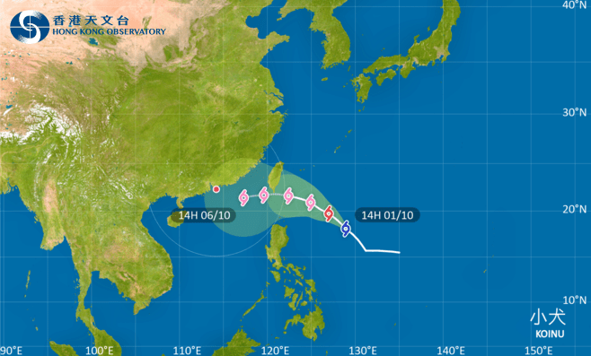
The Observatory forecasts that Typhoon Koinu will enter within 400 kilometers of Hong Kong this Friday (Oct 6).
ADVERTISEMENT
SCROLL TO CONTINUE WITH CONTENT
At noon today, Tropical Storm Koinu was centered about 930 kilometers east-northeast of Manila and was expected to move northwestward with a speed of about 12 kilometers per hour, crossing the waters east of the Philippines and gradually intensifying.
The Observatory expects Koinu to be upgraded to typhoon status on Tuesday (Oct 3) and to Severe Typhoon on Wednesday (Oct 4), while entering 800 kilometers of Hong Kong.
The weather watchdog also forecasts that it will skirt the south of Hong Kong from Friday night to early Saturday morning.
Koinu will move towards the vicinity of the Luzon Strait to the southern part of Taiwan and intensify gradually. The weather will be windier with showers over the coast of Guangdong in the latter part of this week.
According to the 9-day weather forecast, the wind will blow north to northeast at force 5 with force 6 offshore, while mostly cloudy with a few showers on Friday. On Saturday, northeasterly winds were force 5, force 7 offshore and on high ground, as well as mostly cloudy with showers.
Besides, another surge of the northeast monsoon will reach southern China in the middle and latter parts of this week.
Under the influence of the northeast monsoon, there are uncertainties in Koinu’s subsequent movement and intensity.