
Read More







Night Recap - September 15, 2026
8 hours ago




Seven arrested over Kwai Chung illegal gathering
14-09-2026 12:33 HKT
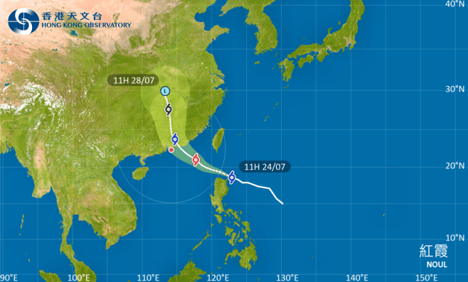
The Hong Kong Observatory will issue the Standby Signal No. 1 at 8.40pm on Friday as Severe Tropical Storm Noul moves closer to the city.
Noul is expected to enter within 800 kilometers of Hong Kong around dusk. At noon, Noul was centered about 480 kilometres north-northeast of Manila and was forecast to strengthen while crossing the northeastern South China Sea on Saturday.
The weather will remain very hot during the day on Saturday, but swells are expected at sea. The public has been advised to stay away from the shoreline and suspend water activities.
Local winds will gradually strengthen later in the day as Noul intensifies and approaches the eastern Guangdong coast, with squally showers becoming more frequent.
The Observatory will consider issuing a higher tropical cyclone warning signal on Saturday afternoon, depending on the storm’s intensity, the distance of its strong winds from Hong Kong and the local wind conditions.
Current assessments suggest Noul is more likely to make landfall over the vicinity of Huizhou to Jieyang early on Sunday, although uncertainty remains over how close it will come to Hong Kong.
The city is expected to experience strong winds, squally heavy showers and thunderstorms on Sunday, with rough seas and large swells.
Residents have been urged to monitor the latest weather information and avoid coastal areas.