Read More
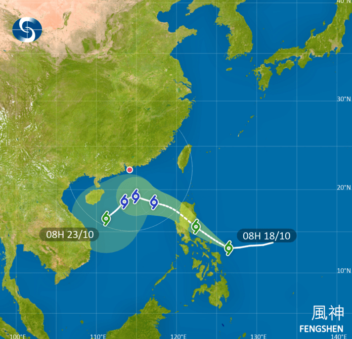
The Hong Kong Observatory (HKO) is considering to issue Strong Wind Signal, No. 3, directly on Monday, as Tropical Cyclone Fengshen approaches within 800 kilometers of Hong Kong, coinciding with a powerful northeast monsoon that will bring strong winds, rain, and cooler temperatures next week.
ADVERTISEMENT
SCROLL TO CONTINUE WITH CONTENT
The HKO is closely monitoring Tropical Cyclone Fengshen, currently near the Philippines, as it approaches the Guangdong coast on Monday.
An intense northeast monsoon, driven by rising pressure over central China, is expected to reach the region on Sunday, October 19, strengthening local winds.
Depending on wind conditions, the Observatory may first issue a Strong Monsoon Signal.
As Fengshen draws closer, the decision to bypass the Standby Signal, No. 1, and directly issue the Strong Wind Signal, No. 3, reflects the cyclone’s anticipated impact.
Fengshen is expected to be closest to Hong Kong on Tuesday, with the Observatory assessing whether higher tropical cyclone warning signals are needed based on the storm’s intensity, the proximity of gale-force winds, and local conditions.
Influenced by the monsoon, Fengshen is likely to shift southwestward, though its exact turning point remains uncertain.
The combined effects of the cyclone and monsoon will bring persistent winds, cloudy skies, and rain early to midweek, with temperatures dropping significantly to around 20 degrees Celsius in urban areas and slightly lower in the New Territories by midweek.
Rough seas and swells are anticipated, and low-lying coastal areas may experience flooding during high tides for several nights next week.
Authorities are urging residents to stay updated with the latest weather reports from the Observatory to prepare for potentially hazardous conditions.