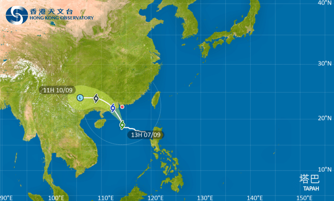
The Strong Wind Signal, No. 3, is expected to remain in force during the daytime on Sunday (Sep 7) as Tropical Storm Tapah edges closer to Hong Kong. The Observatory will assess the need for issuing higher warning signals tonight based on its rate of intensification and its closest distance to the city.
According to the present forecast, Tapah will continue to intensify and skirt around 200 kilometres to the southwest of Hong Kong on Monday (Sep 8) morning.
The forecaster said Tapah was estimated to be about 390 kilometres south of Hong Kong at noon and local winds would strengthen progressively as it edges closer.
Tapah continues to track north-northwestwards at about 16 kilometres per hour. In the past hour, the maximum sustained winds recorded at Tap Mun, Peng Chau, and Cheung Chau were 54, 53, and 44 kilometres per hour, with maximum gusts exceeding 75, 75, and 60 km per hour, respectively.
Meanwhile, heavy squally showers are expected on Monday. The public is advised to stay away from the shoreline and not to engage in water sports as seas will be rough with swells.
“Due to a storm surge, flooding may occur in parts of the low-lying coastal areas tomorrow morning,” the Observatory said.