Read More
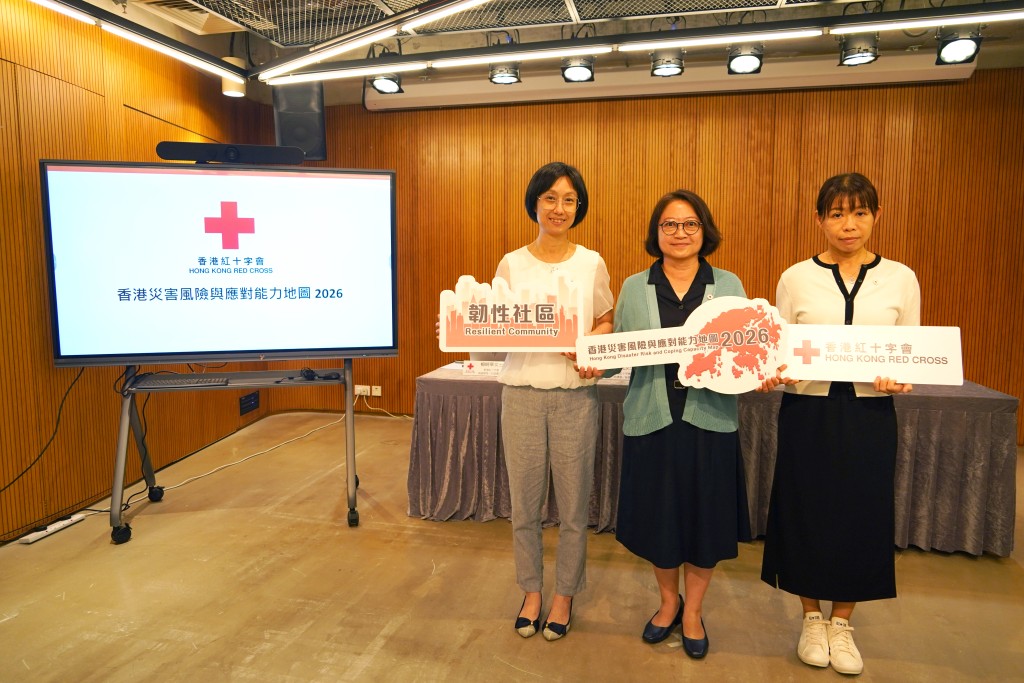
Responding to increasingly complex disaster threats, the Hong Kong Red Cross (HKRC) has released its 'Hong Kong Disaster Risk and Coping Capacity Map 2026', providing an evidence-based picture of how communities across Hong Kong are exposed to typhoons, extreme heat and fires, helping inform disaster preparedness, resource planning and stronger community resilience.
ADVERTISEMENT
SCROLL TO CONTINUE WITH CONTENT
Planning for a safer HK
Rather than responding only after disasters occur, the HKRC believes preparedness begins with understanding where risks are greatest. The 'Hong Kong Disaster Risk and Coping Capacity Map 2026' (the "Disaster Risk Map") is designed to serve as a practical tool for government, community organisations and the public to better understand local vulnerabilities and strengthen preparedness.
Drawing on an internationally recognised disaster risk framework developed by the International Federation of Red Cross and Red Crescent Societies (IFRC) and the United Nations Office for Disaster Risk Reduction (UNDRR), the study combines government statistics, the Planning Department data on Tertiary Planning Units (TPUs), and public survey findings. Using 42 indicators across 292 TPUs, it provides a scientific basis for future planning, resource allocation and community resilience building.
"Looking ahead to Hong Kong's future development planning, this Disaster Risk Map enables various sectors to identify localised disaster risks at the early stages of planning new communities, integrating disaster prevention and preparedness into the city's development blueprint," said Eleanor Lam, Chief Executive Officer / Secretary General of the HKRC.
"As new development areas progress, we look forward to building stronger collaborations with diverse stakeholders, using the Disaster Risk Map to evaluate resource allocation. This will ensure resources respond more flexibly to the actual needs of high-risk areas, allowing community resilience to advance hand-in-hand with urban development."
Five key findings reveal HK's disaster hotspots
The study paints a comprehensive picture of how disaster risks are distributed across Hong Kong, highlighting communities most vulnerable to typhoons, extreme heat and fires, while identifying critical gaps in disaster preparedness.
One of the most significant findings is the growing challenge of compound disasters. Researchers found that more than half of Hong Kong's communities face high or very high risks from at least two types of hazards, meaning many neighbourhoods are vulnerable to multiple disasters rather than a single threat.
Overall, 14.7% of Hong Kong's TPUs were classified as "very high risk", with the five highest-risk TPUs all located in Yuen Long and North District. And more than half of Hong Kong's districts face high-risk threats from two to three types of hazards. Extreme heat also emerged as one of Hong Kong's fastest-growing climate risks. The report found that 42% of Hong Kong's areas face high extreme heat risk, while 34% face very high risk. "Hot Days" are particularly pronounced in parts of the New Territories. For example, San Tin experienced approximately 103 hot days in 2025. Meanwhile, Kowloon is noticeably affected by the urban heat island effect, with Hung Hom recording 54 hot nights in the same year.
Fire risks remain concentrated in some of Hong Kong’s oldest and most populated neighbourhoods, with the five highest-risk areas all located within Yau Tsim Mong. High population density, a greater proportion of low-income households, a shortage of first-aid equipment and lower public awareness of evacuation plans were identified as key contributing factors. The accompanying public survey also revealed that more than 70% of respondents had not participated in a fire drill during the last 12 months, highlighting the need to strengthen community preparedness.
The study also highlights challenges in accessing temporary typhoon shelters. Beyond low-lying and coastal communities, residents living in temporary housing or areas lacking green spaces face elevated typhoon and flooding risks. In some rural districts, residents must travel more than three kilometres to reach the nearest temporary shelter—significantly farther than the territory-wide average of 888 metres—potentially delaying evacuation during severe weather. "The data is not just about measuring risk," Yvonne Yu, Head of Strategic Planning and Humanitarian Diplomacy of the HKRC said during the press conference. "It helps us understand where communities need the greatest support, allowing us to translate research into targeted services that make a tangible difference on the ground."
Turning research into frontline action
For the HKRC, the Disaster Risk Map is more than a research project—it builds on years of frontline experience supporting vulnerable communities across Hong Kong, including Hung Shui Kiu, Tai O and Yau Tsim Mong. The research validates what HKRC staff and volunteers have observed through years of community work while enabling resources to be deployed more strategically.
To address the growing impact of extreme heat, the HKRC distributes cooling supplies and heatstroke prevention information to high-risk groups, including older people, low-income households and outdoor workers ahead of periods of extreme temperatures. Through its 'Extreme Weather Signal Trigger Mechanism’, the organisation also works with community partners to establish temporary cooling and rest stations in high-risk districts whenever severe heat is forecast.
Beyond immediate relief, the HKRC mobilises NGOs, churches, shopping malls, local businesses and volunteers to open community spaces where residents can seek shelter from the heat. By strengthening local networks before disasters occur, the organisation aims to ensure vulnerable groups receive timely humanitarian assistance close to where they live.
Preparing communities before disasters strike
Recognising that disaster risks vary across communities, the HKRC is expanding community-based preparedness programmes tailored to local needs. Rather than adopting a one-size-fits-all approach, the organisation is developing targeted initiatives that address the specific vulnerabilities identified in the Disaster Risk Map. These include customised home improvement projects, such as installing ventilation and cooling devices and carrying out minor repairs in vulnerable households to improve living conditions and reduce disaster risks. The HKRC also conducts first aid, psychological first aid and disaster preparedness workshops, alongside emergency drills that equip residents with practical skills to respond to fires, extreme heat and other emergencies.
To further enhance community resilience, the HKRC supports residents in building neighbourhood support networks, strengthening community connections so people are better prepared to look after one another before, during and after disasters.
Making disaster preparedness part of everyday life
The HKRC believes building resilience extends beyond emergency response and requires ongoing public education.The HKRC has introduced its ‘All-in-One Disaster Preparedness Map’, an online platform integrating real-time weather updates, geospatial information and key public emergency services into a single, easy-to-access resource. The organisation also continues to expand public education initiatives and community outreach programmes, helping more people develop the knowledge, confidence and practical skills needed to respond to emergencies.
By combining scientific research with frontline humanitarian action, the HKRC hopes to help communities prepare earlier, respond faster and recover stronger in the face of future disasters.
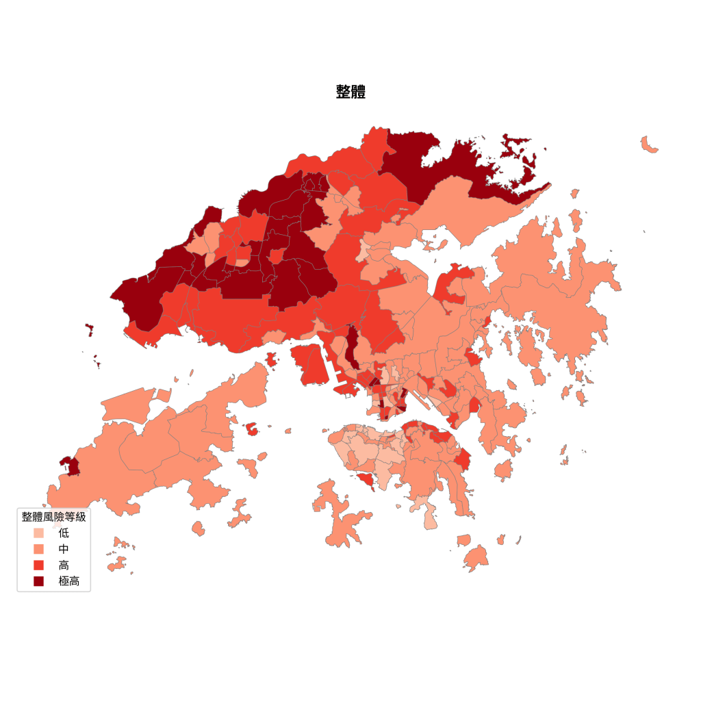
The highest overall risk is located within Tertiary Planning Units (TPUs) in Yuen Long and North District.