Read More
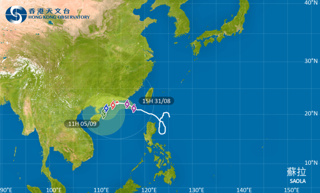
The strong wind signal No 3 was hoisted at 3.40 pm today as Super Typhoon Saola edges closer to Hong Kong, and the Gale or Storm Signal No. 8 will be issued between 2 am and 5 am tomorrow (Sept 1), the Observatory announced.
ADVERTISEMENT
SCROLL TO CONTINUE WITH CONTENT
According to the present forecast, Saola will be relatively close to Hong Kong later tomorrow (Sept 1) posing a threat to Hong Kong.
The weather watchdog made a rare announcement on Thursday that it will issue the Gale or Storm Signal No. 8 tomorrow.
Saola was estimated to be about 380 kilometres east-southeast of Hong Kong just before 4 pm and is forecast to move west-northwest at about 10 kilometers per hour across the northeastern part of the South China Sea and towards the coast of eastern Guangdong.
Local weather is expected to deteriorate significantly with heavy squally showers and violent winds during the daytime tomorrow.
Under the influence of a storm surge, the water level in Hong Kong is expected to rise appreciably towards midnight tomorrow until noon on Saturday (Sept 2). There may be serious flooding in low-lying coastal areas, the Observatory added.