
Read More
The Hong Kong Observatory has published a detailed retrospective on the extraordinary 15-day lifecycle of tropical cyclone Saudel, tracing its dramatic evolution across the northwest Pacific from its initial formation to a rare ocean re-strengthening and its eventual dissipation around midnight on September 4.
ADVERTISEMENT
SCROLL TO CONTINUE WITH CONTENT
The weather authority recounted how the system originally formed as a tropical depression near the Marshall Islands on August 18, fueled by warm sea temperatures and favorable atmospheric conditions to reach super typhoon intensity by August 23.
Guided by a subtropical ridge, it made its first landfall at Yuhuan in Zhejiang Province on the morning of August 28 and weakened into a remnant low-pressure area over land, while retaining enough structural integrity to set the stage for an unusual resurgence.
Interaction with monsoon trough and rare marine revival
Saudel followed an unusual path southward through interaction with a broad trough of low pressure across the northern South China Sea.
Satellite imagery captured the remnant low crossing Hainan Island and re-emerging over water in the afternoon of August 31, where abundant moisture and oceanic energy fueled renewed convective activity.
The system redeveloped into a tropical depression off the southeastern coast of Hainan, prompting the Hong Kong Observatory to issue the Standby Signal No. 1 that evening.
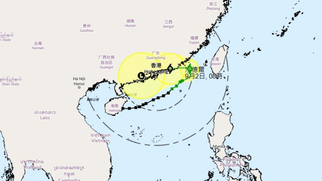
Driven by southwesterly steering currents along the southern side of the broader low-pressure circulation, the revived tropical cyclone tracked east-northeastward across the northern South China Sea, passing roughly 200 kilometers southeast of Hong Kong on September 1.
Its outer rainbands triggered squally showers and thunderstorms locally, though offshore and high-ground gales were tempered across most of the territory due to prevailing northerly winds and local terrain shielding.
Slowing progress and final dissipation
As steering currents weakened on September 2, Saudel slowed down significantly and hovered over the northeastern waters of the South China Sea.
Under the influence of the northeast monsoon, the storm pivoted westward on the morning of September 3, making landfall at Zhangzhou in Fujian province before moving into eastern Guangdong and weakening into a remnant low, leading forecasters to cancel all tropical cyclone warnings around midnight on September 4.
The Observatory noted that while land-to-sea resurgence is rare, meteorological records contain several notable precedents.
Tropical storm Hagibis in 2014 weakened over inland Guangdong after hitting Shantou before regenerating over the East China Sea, while Son-Tinh in 2018 weakened over Vietnam and Laos before re-intensifying over the Gulf of Tonkin, which prompted the Observatory to issue warning signals twice during its lifespan.
Historical looping tracks and local weather outlook
Forecasters also compared Saudel to past systems that executed hairpin or looping tracks near Hong Kong. Tropical storm Pabuk in 2007 made a sharp U-turn near Shangchuan Island after heading south of the territory, heading back toward the Pearl River Estuary.
Even more erratic cases include Typhoon Wayne in 1986 and Typhoon Nat in 1991, each approaching Hong Kong on three separate occasions and necessitating warning signals to be issued and canceled three times.
While Saudel was relatively long-lived at 15 days, it remained shy of the longest-lasting storms in regional records, with Typhoon Rita in 1972, Wayne in 1986, and Noru in 2017 each sustaining tropical cyclone strength for 19 days or more.
With Saudel's extensive journey concluding, cloud cover across the Guangdong coast is expected to thin out, bringing Hong Kong partly sunny conditions alongside a few isolated showers over the coming days.