Read More


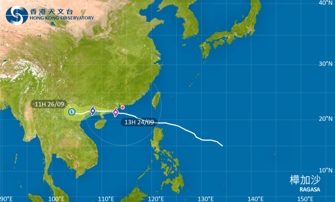
Hong Kong began a cautious recovery on Wednesday afternoon as the Observatory lowered the Hurricane Signal No. 10 to the No. 8 Southeast Gale or Storm Signal at 1.20pm. The T8 signal is expected to remain in force before 8pm tonight.
The storm, which brought the city to a standstill, was centered about 180 kilometers west-southwest of Hong Kong and is forecast to move west or west-northwest at about 22 kilometers per hour, edging closer to the vicinity of the western coast of Guangdong.
Depending on the extent of weakening of local winds, the Observatory will consider issuing the Strong Wind Signal, No. 3.
While the downgrade signals the peak of the crisis has passed, the HKO warned that adverse weather would persist throughout the day, with frequent heavy squally showers and thunderstorms.
Despite the typhoon's movement away from Hong Kong, the public was urged to remain vigilant against significant coastal threats.
Ragasa brought a substantial storm surge and caused a general rise of more than 1.5 meters in water levels over the city, with water levels along the coast generally rising to 3.4 meters or more above chart datum in the morning. The maximum water level at Tai Po Kau and Tsim Bei Tsui tide station was about 3.8 meters above chart datum.
In the past hour, the maximum sustained winds recorded at Ngong Ping, Cheung Chau and Tap Mun were 117, 104 and 91 kilometers per hour with maximum gusts exceeding 156, 123 and 113 kilometers per hour, respectively.
(Updated at 1.57pm)