Read More


Factors at play in US-Iran ceasefire bid | Cash Call | Andrew Wong
20-04-2026 04:31 HKT

Esther Yoo: Being a musician -- Not about romance, but "love"
19-04-2026 16:22 HKT


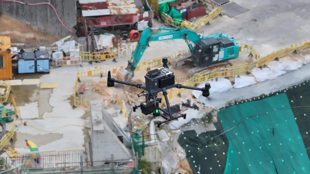
We have been hearing a lot about the new low-altitude economy. It offers a lot of opportunities for food and package delivery, and eventually to rapid passenger transport using small unmanned aircraft – or SUA.
Recent news from the Transport and Logistics Bureau’s low-altitude economy sandbox – highlighting a pilot project by the Development Bureau – has revealed a significant breakthrough. By integrating SUAs with advanced technologies, the project enhances construction site management and operations through remote supervision, significantly reducing manpower and time required for routine inspections and enabling timely checks during adverse weather conditions. It will also reduce risks of injuries and damage to inspection crew and equipment.
In this sandbox, three major breakthroughs have been made. First, larger SUAs with higher payload capacity allow them to be equipped with LiDAR scanner to provide spatial information in addition to images or videos of the site. These SUAs can also be equipped with infra-red thermal images when needed.
Furthermore, flights beyond line of sight can be operated automatically following predetermined flight paths and at scheduled times. It also allows simultaneous operation of SUAs dispatched to different areas, operating from one control room without a need for one-to-one SUA control.
Finally, docking stations enable battery replacements, significantly extending the operational range of SUAs for a much longer range of operation, without concern of battery capacity limits.
For Smart EYE, the spatial information obtained by SUAs can be integrated to the digital platform, which is a tailor-made intelligent solution for real-time and remote supervision recently developed by the Development Bureau.
This innovative system, leveraging advanced edge computing, 5G fusion bonding, large language models and generative AI technologies, can provide comprehensive monitoring data presented on a dashboard, offering full details of the site information to facilitate daily construction management. The advantage of this new system is obvious, as it allows much more efficient joint supervision of client departments, consultants and contractors for quicker identification, follow-up and resolution of problems.
Operations that previously require hours of inspection and discussions can then be executed in minutes, significantly enhancing efficiency of both site inspections and overall site safety.
For example, spatial data on top of imagers or videos of site will provide accurate information on construction progress, timely checking on deviation from design, and early alarm of contravention to site safety. Time-series spatial data captured at regular time intervals will also allow clear and accurate records of site progress against time. Mapped to match design drawings, they will facilitate measurement and provide early warning of works that could deviate from the design drawings. Debates and arguments among a client’s departments, consultants and the contractors can then be minimized.
The above technological breakthroughs for remote supervision could lead to transformative changes to three major targets of applications, including site management, emergency response and asset management.
Site inspections that previously require deployment of teams of engineers from various departments can now be done remotely from individual offices, without the need for physical presence.
Any deviations from planned activities can be picked up quickly and dealt with, dispensing with the need to hold ad hoc meetings to resolve them. Instead, based on the detailed information becoming available to individual officers at their normal work desks, it will facilitate efficient planning of resolving actions through routine communication channels by phone or email. The improvement in efficiency and the reduction in manpower and time will be significant.
Another application area is for dealing with emergencies arising from adverse weather, which requires quick action. With the ever-increasing occurrence of inclement weather causing landslides and flooding, quick assessment of any damage can be performed, significantly reducing the time to prepare for immediate remedial actions and plans for reinstatement. Dispatch of emergency equipment can be done much more efficiently.
The days of gathering special teams in anticipation of adverse weather conditions and dispensing them to cross difficult terrain to get to sites to provide emergency relief activities and the resulting risks of injuries and damage will soon be over. Such valuable resources can be deployed for more effective planning and other important duties.
It is also worthwhile to highlight another useful application on asset management. Regular LiDAR scanning and thermal image shoots will provide a continuous record of the conditions of large facilities to assist planned maintenance, and to ensure correct operation, providing round-the-clock surveillance, minimizing occurrence of unauthorized trespassing and other unauthorized activities.
Once again, in addition to the implementation at 12 applicable sites under this sandbox initiative, our government is now embarking on bold and well-informed new steps to enhance efficiency and effectiveness. We can look forward to more advancements like these in the near future – paving the way for a smarter, safer and better city.
Veteran engineer Edmund Leung Kwong-ho casts an expert eye over features of modern life